
Land guide · Water
How deep are wells in the Texas Hill Country? (by county)
Across 22,436 state well records in Hays, Travis, Comal, Blanco, Caldwell and Bastrop counties, the typical water well was drilled to about 420 feet. Half were between about 270 and 560 feet. But it swings a lot from county to county, and even mile to mile.
Typical well depth by county
| County | Typical depth | Middle half | Well records |
|---|---|---|---|
| Hays | about 500 ft | 400–700 ft | 4,186 |
| Travis | about 420 ft | 260–620 ft | 5,677 |
| Comal | about 480 ft | 380–600 ft | 4,586 |
| Blanco | about 350 ft | 210–460 ft | 3,482 |
| Caldwell | about 240 ft | 160–350 ft | 1,435 |
| Bastrop | about 320 ft | 210–460 ft | 3,070 |
"Typical" is the median: half the wells are shallower, half are deeper. "Middle half" is the range from the 25th to the 75th percentile. Rounded to the nearest 10 feet.
See it on the map
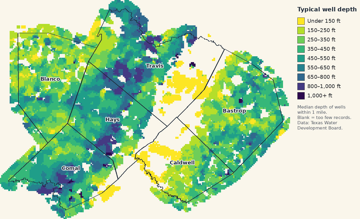
Open the zoomable well-depth map
Near town
Typical depth of wells within 3 miles of each town (towns with at least 20 records nearby).
| Town | County | Typical depth | Wells |
|---|---|---|---|
| San Marcos | Hays | about 180 ft | 51 |
| Kyle | Hays | about 430 ft | 62 |
| Buda | Hays | about 410 ft | 140 |
| Wimberley | Hays | about 650 ft | 307 |
| Woodcreek | Hays | about 440 ft | 180 |
| Dripping Springs | Hays | about 510 ft | 211 |
| Austin | Travis | about 400 ft | 422 |
| Bee Cave | Travis | about 820 ft | 265 |
| Lakeway | Travis | about 560 ft | 277 |
| Lago Vista | Travis | about 400 ft | 167 |
| Pflugerville | Travis | about 610 ft | 48 |
| New Braunfels | Comal | about 150 ft | 69 |
| Canyon Lake | Comal | about 340 ft | 143 |
| Bulverde | Comal | about 500 ft | 525 |
| Garden Ridge | Comal | about 440 ft | 171 |
| Johnson City | Blanco | about 300 ft | 287 |
| Blanco | Blanco | about 400 ft | 175 |
| Round Mountain | Blanco | about 300 ft | 86 |
| Lockhart | Caldwell | about 40 ft | 53 |
| Luling | Caldwell | about 260 ft | 93 |
| Martindale | Caldwell | about 40 ft | 56 |
| Bastrop | Bastrop | about 280 ft | 160 |
| Elgin | Bastrop | about 180 ft | 23 |
| Smithville | Bastrop | about 340 ft | 112 |
Are wells getting deeper?
Here's the typical depth by the year the well was drilled, all six counties together. Older records are fewer and spottier, so take the early numbers loosely.
| Drilled | Typical depth | Wells |
|---|---|---|
| before 1980 | about 270 ft | 2,317 |
| 1980–1999 | about 450 ft | 736 |
| 2000–2009 | about 440 ft | 6,589 |
| 2010–2019 | about 440 ft | 7,138 |
| 2020 and later | about 430 ft | 4,571 |
Hays County water notice
As of October 15, 2026, the Hays Trinity Groundwater Conservation District (western Hays County) says it is in Emergency Drought Stage and won't accept new permits for production or non-exempt well construction until conditions improve. Household (exempt) wells still need the district's forms before drilling. Source: the district's website.
What these numbers can and can't tell you
- It's drilled depth, not water depth. A well drilled to 500 feet may have water standing much higher in the hole.
- Your land is its own place. Neighbors a mile apart can hit very different rock. A licensed local driller who has worked your area is the best person to ask.
- Check the groundwater district first. Most districts here want a new well registered, and some want a drilling authorization, before anyone drills. Each county page lists the districts and their rules.
- Ask about yield, too. Drillers' short pump tests don't show how a well holds up in a dry summer. Ask the neighbors.
Common questions
How deep is a typical water well in the Texas Hill Country?
In our count of 22,436 state well records across Hays, Travis, Comal, Blanco, Caldwell and Bastrop counties, the typical (median) well was drilled to about 420 feet, and half were between about 270 and 560 feet.
Which county has the deepest wells?
Of these six, Hays County's wells run deepest, at a typical 500 feet. Caldwell County's run shallowest, at about 240 feet.
Does the depth of nearby wells tell me how deep my well will be?
Not for sure. It's a good starting point, but depths can change a lot within a few miles. Ask a licensed local well driller and the groundwater district before you buy or drill.
Where does this data come from?
From the Texas Water Development Board's Groundwater Database and Submitted Drillers Reports, which we downloaded and counted ourselves. Monitoring, test and environmental wells are left out.
Where the numbers come from
We counted water-supply well records from Texas Water Development Board, Groundwater Database (GWDB) bulk download (download, data as of 2026-10-13) and Texas Water Development Board, Submitted Drillers Reports (SDR) bulk download (download, data as of 2026-10-13). Water-supply wells only (monitoring, test and environmental wells left out). Depth is how deep the well was drilled. A well listed in both TWDB databases is counted once. County figures count wells inside the county line. County lines: US Census Bureau TIGERweb. Updated 2026-10-15.
Looking at a piece of land?
Our free snapshot shows the wells near your exact spot, plus flooding, road access and county records, in about 30 seconds.
Check my land freeThis guide is general information from public records, not a guarantee for any property and not legal or engineering advice.